
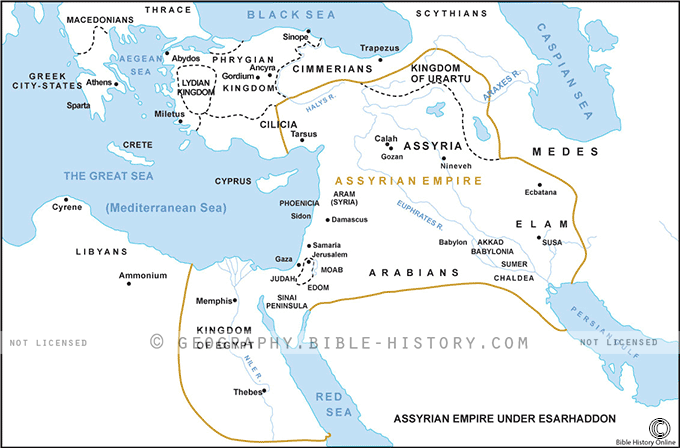
The map of the Assyrian Empire under Esarhaddon provides a captivating visual representation of the ancient empire during the reign of King Esarhaddon (reigned from 681 to 669 BCE). This historical map offers insights into the geographical extent, key cities, and notable achievements of the Assyrian Empire during this period. Here is a description of this intriguing map:
Geographical Extent:
This map showcases the territorial boundaries of the Assyrian Empire under Esarhaddon's rule. The empire covered vast regions of the ancient Near East, including parts of modern-day Iraq, Syria, Turkey, Iran, and beyond. It portrays the empire as it reached its zenith during this period.
Central Cities and Regions:
- Nineveh: As the capital city of the Assyrian Empire, Nineveh takes center stage on the map. It was a thriving metropolis and a symbol of Assyrian power, known for its impressive architecture and monumental structures.
- Babylon: The map includes Babylon, which Esarhaddon successfully conquered and ruled. The inclusion of Babylon underscores the Assyrian Empire's dominance over the region.
Military Campaigns and Conquests:
Markers on the map highlight the routes and locations of Esarhaddon's military campaigns. These campaigns were instrumental in expanding and maintaining the empire's control over various regions and territories.
Transportation and Trade Routes:
The map depicts significant transportation and trade routes, which were essential for the movement of armies, communication, and the exchange of goods within the empire. These routes played a crucial role in the administration of the vast empire.
Cultural and Historical Significance:
This map serves as a testament to the cultural and historical importance of the Assyrian Empire under Esarhaddon. It was a period of continued innovation and influence in governance, art, and architecture.
Legacy and Archaeological Sites:
The map also points to archaeological sites associated with the Assyrian Empire. These sites have yielded invaluable artifacts, inscriptions, and historical records that shed light on the empire's civilization and history.
The map of the Assyrian Empire under Esarhaddon offers an engaging opportunity to explore the grandeur and reach of one of the most formidable empires in antiquity. It invites viewers to appreciate the empire's territorial expansion, military achievements, cultural contributions, and its enduring impact on the history of the ancient Near East.
Blank Topo Map of The World
Abraham’s Journey
The Captivity of Judah (586-516 B.C.)
The Fall of Judah 586 B.C.
The Northern Kingdom of Israel
The Southern Kingdom of Judah
The Divided Kingdom
The Fertile Crescent
Ur of the Chaldees
Shechem in Old Testament Times
Prophets, Kings, and Nations
Jesus Last Passover
New Testament Israel
New Testament Places
Old Testament Israel
Provinces of the Roman Empire
Israel during David’s Kingdom
David’s Kingdom
Cities of the New Testament 4
Cities of the New Testament 3
Cities of the New Testament 2
Mediterranean Sea
Cities of the New Testament
First Century Jerusalem
Empire of David and Solomon
David’s Kingdom
Israel Under Rehoboam
Ophir and Tarshish
The Period of the Kings
Ramoth Gilead
Samaria
Solomon’s Temple
Zarephath and MT Carmel
Jabesh Gilead and Tribes
Judah in the Time of David
Kingdom of Saul
Kirjath Jearim
Michmash
Mount Gilboa in the Time of David
Nob Davids Flight
Shiloh
Israel and Judah
Assyrian Empire Under Esarhaddon
Assyrian Empire Under Sennacherib
Captivity of 10 Tribes
Events in 2 Kings
The Khabur River
Israel and Syria
Captives From Judah
Kingdom of Jeroboam
Mesha’s Kingdom
Pharaoh Necho Battles King Josiah at Megiddo
Babylonian, Mede and Persian Empires
Samaria and Nearby Territories
Syria at its Height
Hebron
Mahanaim
1949 Map of Israel With Boundaries
First & Second Journeys of Paul
Journeys of the Apostles
Paul’s Third Missionary Journey
Saul’s Journey to Damascus and Arabia
Paul’s Final Visits
Paul’s 1st Missionary Journey
Paul’s 2nd Missionary Journey
Paul’s 3rd Missionary Journey
Paul’s Voyage to Rome
Phillip Journeys to Samaria and Gaza
Judah at the Time of Amos
Empire of Alexander the Great
Israel Under the Maccabees
Galilee During Maccabees
Idumea Intertestamental Period
Kingdom of the Ptolemies
Kingdom of the Seleucids
Ptolemaic Egypt Seleucid Asia
The Roman World
Kingdom of Ptolemies and Seleucids
The World During the 6TH Century BC
Mount Horeb
The Red Sea
The Exodus
Ezra’s Journey to Restore Jerusalem
Israel and Judah During Hosea’s Time
The Ancient World
Canaan During the Time of Abraham
The City of Shechem
Supposed Location of the Garden of Eden
The Land of Israel in Genesis
The Jordan River
The Kingdom of Nimrod
Mount Ararat and Mesopotamia
The Descendants
Sodom and Gomorrah
The Kingdom of Egypt
The Hamites
The Kingdom of the Hittites
Ur of the Chaldees
Judah at the Time of Haggai
Jesus Passes Through Samaria