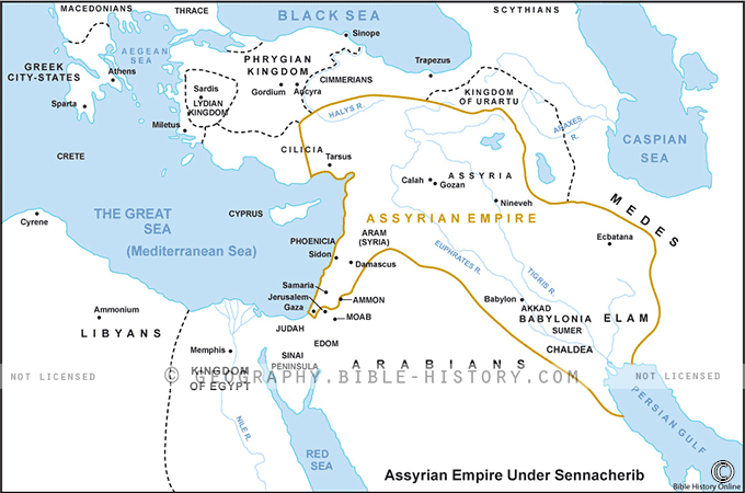

The map of the Assyrian Empire under Sennacherib offers a vivid portrayal of one of the most powerful and influential empires in the ancient world during the reign of King Sennacherib (705–681 BCE). Here is a description of this historical map:
Geographical Extent:
This map showcases the vast territorial expanse of the Assyrian Empire at the height of its power during the reign of Sennacherib. The empire spanned parts of modern-day Iraq, Syria, Turkey, and Iran, encompassing a vast and diverse landscape.
Key Cities and Regions:
- Nineveh (Ninua): The capital city of the Assyrian Empire, Nineveh, occupies a central position on the map. It was a grand metropolis and the political and cultural heart of the empire.
- Babylon: The map includes Babylon, which was conquered and ruled by Sennacherib during his reign, marking a significant expansion of the Assyrian Empire's influence.
- Trade Routes: The map highlights major trade routes, such as the Royal Road, which connected Nineveh to various parts of the empire and facilitated trade, communication, and the movement of armies.
Military Campaigns:
Markers on the map indicate the routes and locations of Sennacherib's military campaigns. These campaigns included conflicts with rival kingdoms, the suppression of rebellions, and efforts to expand and consolidate Assyrian control.
Architectural Marvels:
Sennacherib is known for his architectural achievements, including the construction of the grand Palace without Rival in Nineveh. The map highlights architectural landmarks and fortifications associated with his reign.
Cultural and Historical Significance:
This map is not just a representation of territorial conquests but a visual testament to the cultural and historical significance of the Assyrian Empire under Sennacherib. It was a time of great innovation in terms of governance, engineering, and the arts.
Legacy and Archaeological Discoveries:
The map also serves as a gateway to the archaeological sites associated with the Assyrian Empire. Numerous artifacts, inscriptions, and ruins provide valuable insights into the civilization and history of this ancient empire.
The map of the Assyrian Empire under Sennacherib offers a remarkable opportunity to explore the reach and influence of one of the most formidable empires of antiquity. It allows viewers to appreciate the empire's territorial expanse, military prowess, architectural achievements, and its enduring impact on the course of ancient history in the Near East.
Blank Topo Map of The World
Abraham’s Journey
The Captivity of Judah (586-516 B.C.)
The Fall of Judah 586 B.C.
The Northern Kingdom of Israel
The Southern Kingdom of Judah
The Divided Kingdom
The Fertile Crescent
Ur of the Chaldees
Shechem in Old Testament Times
Prophets, Kings, and Nations
Jesus Last Passover
New Testament Israel
New Testament Places
Old Testament Israel
Provinces of the Roman Empire
Israel during David’s Kingdom
David’s Kingdom
Cities of the New Testament 4
Cities of the New Testament 3
Cities of the New Testament 2
Mediterranean Sea
Cities of the New Testament
First Century Jerusalem
Empire of David and Solomon
David’s Kingdom
Israel Under Rehoboam
Ophir and Tarshish
The Period of the Kings
Ramoth Gilead
Samaria
Solomon’s Temple
Zarephath and MT Carmel
Jabesh Gilead and Tribes
Judah in the Time of David
Kingdom of Saul
Kirjath Jearim
Michmash
Mount Gilboa in the Time of David
Nob Davids Flight
Shiloh
Israel and Judah
Assyrian Empire Under Esarhaddon
Assyrian Empire Under Sennacherib
Captivity of 10 Tribes
Events in 2 Kings
The Khabur River
Israel and Syria
Captives From Judah
Kingdom of Jeroboam
Mesha’s Kingdom
Pharaoh Necho Battles King Josiah at Megiddo
Babylonian, Mede and Persian Empires
Samaria and Nearby Territories
Syria at its Height
Hebron
Mahanaim
1949 Map of Israel With Boundaries
First & Second Journeys of Paul
Journeys of the Apostles
Paul’s Third Missionary Journey
Saul’s Journey to Damascus and Arabia
Paul’s Final Visits
Paul’s 1st Missionary Journey
Paul’s 2nd Missionary Journey
Paul’s 3rd Missionary Journey
Paul’s Voyage to Rome
Phillip Journeys to Samaria and Gaza
Judah at the Time of Amos
Empire of Alexander the Great
Israel Under the Maccabees
Galilee During Maccabees
Idumea Intertestamental Period
Kingdom of the Ptolemies
Kingdom of the Seleucids
Ptolemaic Egypt Seleucid Asia
The Roman World
Kingdom of Ptolemies and Seleucids
The World During the 6TH Century BC
Mount Horeb
The Red Sea
The Exodus
Ezra’s Journey to Restore Jerusalem
Israel and Judah During Hosea’s Time
The Ancient World
Canaan During the Time of Abraham
The City of Shechem
Supposed Location of the Garden of Eden
The Land of Israel in Genesis
The Jordan River
The Kingdom of Nimrod
Mount Ararat and Mesopotamia
The Descendants
Sodom and Gomorrah
The Kingdom of Egypt
The Hamites
The Kingdom of the Hittites
Ur of the Chaldees
Judah at the Time of Haggai
Jesus Passes Through Samaria