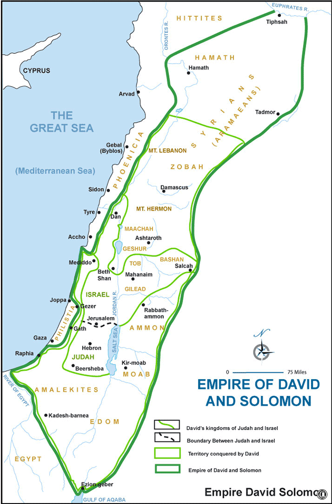

The map of the Empire of David and Solomon offers a captivating visual representation of a legendary and prosperous period in the history of ancient Israel. Under the rule of David and his son Solomon, the boundaries of the Israelite kingdom expanded significantly, and the nation achieved a zenith of wealth and influence. Here is a description of this historical map:
Geographical Scope:
This map provides a comprehensive view of the extensive territory that constituted the Empire of David and Solomon. It encompasses not only the core regions of ancient Israel but also areas that were subject to Israelite influence and control.
Capital Cities:
The map prominently features Jerusalem as the capital city of this empire, showcasing its central role in political, religious, and administrative affairs. It may also indicate other significant cities within the empire.
Conquests and Expansion:
It outlines the routes and locations of the military campaigns and conquests led by David and Solomon, which resulted in the extension of Israelite rule over neighboring nations.
Key Trade Routes:
The map may highlight trade routes that were crucial for the prosperity of the empire, including land-based routes and maritime connections that facilitated commerce with distant regions.
Architectural Achievements:
It showcases the architectural marvels of the time, such as the construction of the First Temple in Jerusalem, Solomon's palaces, and fortifications that protected the empire.
Religious Significance:
The map indicates religious sites and places of worship, reflecting the centralization of religious practices in Jerusalem and the profound influence of the Ark of the Covenant.
Political and Historical Context:
This map serves as a visual portal into the political landscape and historical events that shaped the Empire of David and Solomon. It was an era of consolidation, prosperity, and diplomatic relations with neighboring kingdoms.
Cultural Insights:
Exploring the map allows viewers to gain insights into the culture, society, and governance of the people during this golden age. It offers a connection to the customs, laws, and artistic achievements of the era.
Legacy and Influence:
The map may highlight the enduring legacy of David and Solomon as visionary leaders, poets, and builders who left an indelible mark on the history of Israel.
The map of the Empire of David and Solomon offers a captivating journey into a period of expansion, prosperity, and cultural flourishing in ancient Israel. It allows viewers to explore the geography, politics, and history of this iconic era, providing a deeper understanding of the events and stories that defined the biblical narrative of David and Solomon's empire.
Blank Topo Map of The World
Abraham’s Journey
The Captivity of Judah (586-516 B.C.)
The Fall of Judah 586 B.C.
The Northern Kingdom of Israel
The Southern Kingdom of Judah
The Divided Kingdom
The Fertile Crescent
Ur of the Chaldees
Shechem in Old Testament Times
Prophets, Kings, and Nations
Jesus Last Passover
New Testament Israel
New Testament Places
Old Testament Israel
Provinces of the Roman Empire
Israel during David’s Kingdom
David’s Kingdom
Cities of the New Testament 4
Cities of the New Testament 3
Cities of the New Testament 2
Mediterranean Sea
Cities of the New Testament
First Century Jerusalem
Empire of David and Solomon
David’s Kingdom
Israel Under Rehoboam
Ophir and Tarshish
The Period of the Kings
Ramoth Gilead
Samaria
Solomon’s Temple
Zarephath and MT Carmel
Jabesh Gilead and Tribes
Judah in the Time of David
Kingdom of Saul
Kirjath Jearim
Michmash
Mount Gilboa in the Time of David
Nob Davids Flight
Shiloh
Israel and Judah
Assyrian Empire Under Esarhaddon
Assyrian Empire Under Sennacherib
Captivity of 10 Tribes
Events in 2 Kings
The Khabur River
Israel and Syria
Captives From Judah
Kingdom of Jeroboam
Mesha’s Kingdom
Pharaoh Necho Battles King Josiah at Megiddo
Babylonian, Mede and Persian Empires
Samaria and Nearby Territories
Syria at its Height
Hebron
Mahanaim
1949 Map of Israel With Boundaries
First & Second Journeys of Paul
Journeys of the Apostles
Paul’s Third Missionary Journey
Saul’s Journey to Damascus and Arabia
Paul’s Final Visits
Paul’s 1st Missionary Journey
Paul’s 2nd Missionary Journey
Paul’s 3rd Missionary Journey
Paul’s Voyage to Rome
Phillip Journeys to Samaria and Gaza
Judah at the Time of Amos
Empire of Alexander the Great
Israel Under the Maccabees
Galilee During Maccabees
Idumea Intertestamental Period
Kingdom of the Ptolemies
Kingdom of the Seleucids
Ptolemaic Egypt Seleucid Asia
The Roman World
Kingdom of Ptolemies and Seleucids
The World During the 6TH Century BC
Mount Horeb
The Red Sea
The Exodus
Ezra’s Journey to Restore Jerusalem
Israel and Judah During Hosea’s Time
The Ancient World
Canaan During the Time of Abraham
The City of Shechem
Supposed Location of the Garden of Eden
The Land of Israel in Genesis
The Jordan River
The Kingdom of Nimrod
Mount Ararat and Mesopotamia
The Descendants
Sodom and Gomorrah
The Kingdom of Egypt
The Hamites
The Kingdom of the Hittites
Ur of the Chaldees
Judah at the Time of Haggai
Jesus Passes Through Samaria