
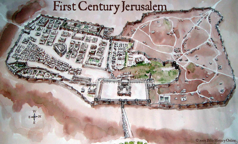
The map of First Century Jerusalem offers a captivating visual journey into the heart of a historically significant city during a pivotal era in antiquity. Jerusalem, the capital of ancient Judea, was not only a vibrant urban center but also the epicenter of religious, cultural, and political life in the region. Here is a description of this historical map:
Geographical Context:
This map provides an intricate depiction of the geographical layout of First Century Jerusalem. It highlights the topography, including the hills, valleys, and key landmarks that defined the city's landscape.
City of Jerusalem:
The map prominently features the city of Jerusalem itself, showcasing its walls, gates, and the various quarters within the city, such as the Temple Mount, the City of David, and the various markets and neighborhoods.
Religious Significance:
This map serves as a visual portal into the religious significance of First Century Jerusalem. It highlights the Second Temple, its courtyards, and the Western Wall, which remains a sacred site for Jewish worship and reflection today.
Historical Context:
The map provides historical context for First Century Jerusalem, including its role under Roman rule during the time of Herod the Great and the later Roman governors. It also reflects the various factions and religious groups that inhabited the city, such as the Pharisees, Sadducees, Zealots, and Essenes.
Cultural and Architectural Insights:
Exploring the map allows viewers to gain insights into the culture, society, and architectural achievements of the people living in First Century Jerusalem. It offers a glimpse into the daily life, customs, and challenges faced by the city's inhabitants.
Trade and Commerce:
The map may indicate trade routes, markets, and commercial activities within the city, reflecting Jerusalem's role as a hub for trade and commerce in the region.
Landmarks and Places of Interest:
It showcases significant landmarks and places of interest, such as the Antonia Fortress, the Pool of Siloam, the Garden of Gethsemane, and the Bethesda Pool, all of which are central to the events and stories of the period.
Religious Festivals and Events:
The map may highlight the locations where religious festivals and events, such as Passover and the Feast of Tabernacles, were celebrated, providing insights into the spiritual life of the city.
The map of First Century Jerusalem invites viewers to step into the heart of an ancient city that was not only a political and cultural center but also a place of profound religious significance. It offers a comprehensive view of the geography, history, and cultural context of Jerusalem during this transformative period, enriching our understanding of the events and stories that unfolded in this iconic city.
Blank Topo Map of The World
Abraham’s Journey
The Captivity of Judah (586-516 B.C.)
The Fall of Judah 586 B.C.
The Northern Kingdom of Israel
The Southern Kingdom of Judah
The Divided Kingdom
The Fertile Crescent
Ur of the Chaldees
Shechem in Old Testament Times
Prophets, Kings, and Nations
Jesus Last Passover
New Testament Israel
New Testament Places
Old Testament Israel
Provinces of the Roman Empire
Israel during David’s Kingdom
David’s Kingdom
Cities of the New Testament 4
Cities of the New Testament 3
Cities of the New Testament 2
Mediterranean Sea
Cities of the New Testament
First Century Jerusalem
Empire of David and Solomon
David’s Kingdom
Israel Under Rehoboam
Ophir and Tarshish
The Period of the Kings
Ramoth Gilead
Samaria
Solomon’s Temple
Zarephath and MT Carmel
Jabesh Gilead and Tribes
Judah in the Time of David
Kingdom of Saul
Kirjath Jearim
Michmash
Mount Gilboa in the Time of David
Nob Davids Flight
Shiloh
Israel and Judah
Assyrian Empire Under Esarhaddon
Assyrian Empire Under Sennacherib
Captivity of 10 Tribes
Events in 2 Kings
The Khabur River
Israel and Syria
Captives From Judah
Kingdom of Jeroboam
Mesha’s Kingdom
Pharaoh Necho Battles King Josiah at Megiddo
Babylonian, Mede and Persian Empires
Samaria and Nearby Territories
Syria at its Height
Hebron
Mahanaim
1949 Map of Israel With Boundaries
First & Second Journeys of Paul
Journeys of the Apostles
Paul’s Third Missionary Journey
Saul’s Journey to Damascus and Arabia
Paul’s Final Visits
Paul’s 1st Missionary Journey
Paul’s 2nd Missionary Journey
Paul’s 3rd Missionary Journey
Paul’s Voyage to Rome
Phillip Journeys to Samaria and Gaza
Judah at the Time of Amos
Empire of Alexander the Great
Israel Under the Maccabees
Galilee During Maccabees
Idumea Intertestamental Period
Kingdom of the Ptolemies
Kingdom of the Seleucids
Ptolemaic Egypt Seleucid Asia
The Roman World
Kingdom of Ptolemies and Seleucids
The World During the 6TH Century BC
Mount Horeb
The Red Sea
The Exodus
Ezra’s Journey to Restore Jerusalem
Israel and Judah During Hosea’s Time
The Ancient World
Canaan During the Time of Abraham
The City of Shechem
Supposed Location of the Garden of Eden
The Land of Israel in Genesis
The Jordan River
The Kingdom of Nimrod
Mount Ararat and Mesopotamia
The Descendants
Sodom and Gomorrah
The Kingdom of Egypt
The Hamites
The Kingdom of the Hittites
Ur of the Chaldees
Judah at the Time of Haggai
Jesus Passes Through Samaria