
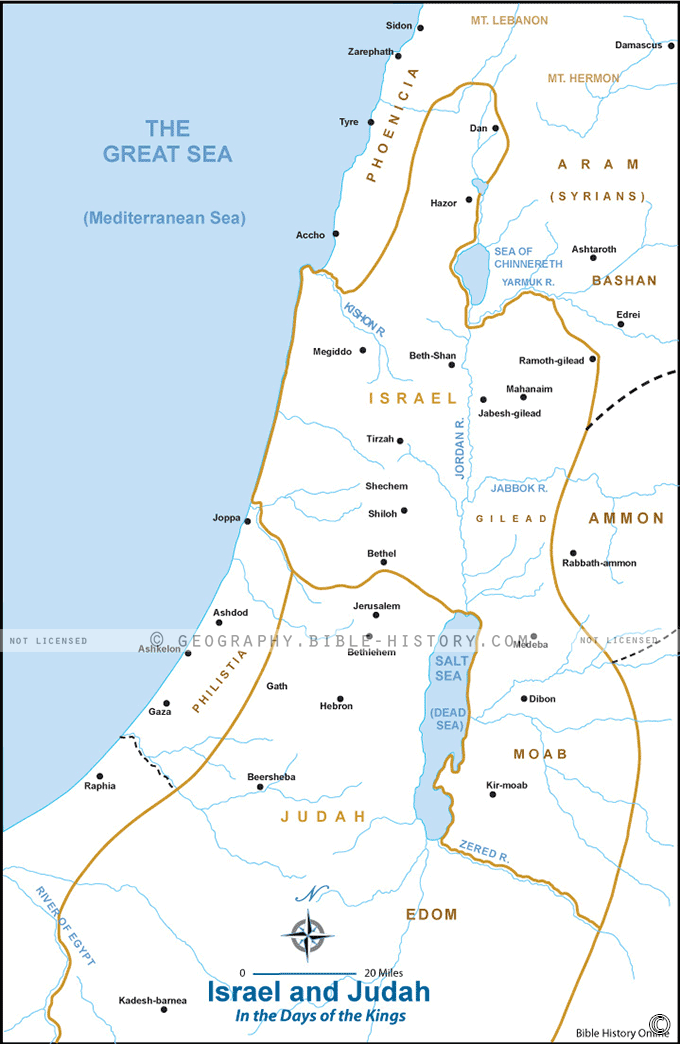
The map of ancient Israel and Judah is a captivating representation of a pivotal period in history, showcasing the geographical and political landscape of the region as it appears in the Old Testament of the Bible.
Here is a description of this historical map:
Geographical Context:
This map provides a comprehensive view of the lands of Israel and Judah, highlighting the topographical features and natural boundaries of the region. To the west, the Mediterranean Sea offers access to trade routes and maritime activities, while to the east, rugged hills and mountains define the landscape.
Prominent Cities and Regions:
- Jerusalem: At the heart of the map stands Jerusalem, the capital of the southern kingdom of Judah. It is the spiritual and political center of the Israelite people and is home to the First and Second Temples.
- Samaria: In the northern region, the city of Samaria serves as the capital of the northern kingdom of Israel. It is a significant center for political and religious activities.
- Bethlehem: Located south of Jerusalem, Bethlehem is renowned as the birthplace of King David and, according to the New Testament, Jesus.
- Judean Desert and Jordan River: The map features the Judean Desert to the east and the Jordan River, a critical water source and site of several biblical events.
Kingdoms and Territories:
The map distinguishes between the kingdoms of Israel and Judah, highlighting their respective borders and territories. This division, stemming from the reign of King Solomon's son, Rehoboam, plays a central role in biblical narratives.
Trade Routes:
Numerous trade routes traverse the region, connecting Israel and Judah to neighboring lands such as Egypt, Mesopotamia, and Arabia. These routes facilitated the exchange of goods, cultures, and ideas.
Religious and Historical Significance:
This map is more than just a geographical representation; it serves as a window into a world where the stories of the Old Testament unfolded. It reflects the journeys of biblical figures like Abraham, Moses, David, and Solomon and the religious events that define the history of Judaism and, to some extent, Christianity.
Archaeological and Cultural Insights:
In addition to its religious significance, the map highlights archaeological sites and areas of historical interest where excavations have unearthed ancient artifacts, inscriptions, and structures that provide valuable insights into the lives of the people who inhabited this region.
The map of ancient Israel and Judah offers a captivating glimpse into a bygone era, where the destinies of nations, the lives of prophets and kings, and the foundations of two major world religions were intricately woven into the diverse and challenging landscape of the biblical lands.
Blank Topo Map of The World
Abraham’s Journey
The Captivity of Judah (586-516 B.C.)
The Fall of Judah 586 B.C.
The Northern Kingdom of Israel
The Southern Kingdom of Judah
The Divided Kingdom
The Fertile Crescent
Ur of the Chaldees
Shechem in Old Testament Times
Prophets, Kings, and Nations
Jesus Last Passover
New Testament Israel
New Testament Places
Old Testament Israel
Provinces of the Roman Empire
Israel during David’s Kingdom
David’s Kingdom
Cities of the New Testament 4
Cities of the New Testament 3
Cities of the New Testament 2
Mediterranean Sea
Cities of the New Testament
First Century Jerusalem
Empire of David and Solomon
David’s Kingdom
Israel Under Rehoboam
Ophir and Tarshish
The Period of the Kings
Ramoth Gilead
Samaria
Solomon’s Temple
Zarephath and MT Carmel
Jabesh Gilead and Tribes
Judah in the Time of David
Kingdom of Saul
Kirjath Jearim
Michmash
Mount Gilboa in the Time of David
Nob Davids Flight
Shiloh
Israel and Judah
Assyrian Empire Under Esarhaddon
Assyrian Empire Under Sennacherib
Captivity of 10 Tribes
Events in 2 Kings
The Khabur River
Israel and Syria
Captives From Judah
Kingdom of Jeroboam
Mesha’s Kingdom
Pharaoh Necho Battles King Josiah at Megiddo
Babylonian, Mede and Persian Empires
Samaria and Nearby Territories
Syria at its Height
Hebron
Mahanaim
1949 Map of Israel With Boundaries
First & Second Journeys of Paul
Journeys of the Apostles
Paul’s Third Missionary Journey
Saul’s Journey to Damascus and Arabia
Paul’s Final Visits
Paul’s 1st Missionary Journey
Paul’s 2nd Missionary Journey
Paul’s 3rd Missionary Journey
Paul’s Voyage to Rome
Phillip Journeys to Samaria and Gaza
Judah at the Time of Amos
Empire of Alexander the Great
Israel Under the Maccabees
Galilee During Maccabees
Idumea Intertestamental Period
Kingdom of the Ptolemies
Kingdom of the Seleucids
Ptolemaic Egypt Seleucid Asia
The Roman World
Kingdom of Ptolemies and Seleucids
The World During the 6TH Century BC
Mount Horeb
The Red Sea
The Exodus
Ezra’s Journey to Restore Jerusalem
Israel and Judah During Hosea’s Time
The Ancient World
Canaan During the Time of Abraham
The City of Shechem
Supposed Location of the Garden of Eden
The Land of Israel in Genesis
The Jordan River
The Kingdom of Nimrod
Mount Ararat and Mesopotamia
The Descendants
Sodom and Gomorrah
The Kingdom of Egypt
The Hamites
The Kingdom of the Hittites
Ur of the Chaldees
Judah at the Time of Haggai
Jesus Passes Through Samaria