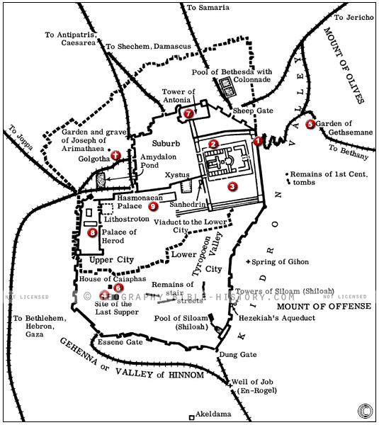

The map of Jesus' Last Passover provides a vivid and immersive portrayal of the significant events leading up to the crucifixion of Jesus Christ, including his final Passover meal with his disciples. This interactive map allows viewers to explore the geographical and historical context of these pivotal moments in the New Testament. Here is a description of this historical map:
Geographical Setting:
This map offers a detailed view of the geographical landscape surrounding Jerusalem during the time of Jesus. It encompasses the city of Jerusalem and its surroundings, including the Kidron Valley, the Mount of Olives, and the paths leading to the Garden of Gethsemane.
Jerusalem:
The map prominently features Jerusalem, the holy city, and its key landmarks such as the Temple Mount, the Upper Room, and the site traditionally associated with the Last Supper.
Events of the Last Passover:
It chronicles the events leading up to Jesus' crucifixion, including his entry into Jerusalem on Palm Sunday, the cleansing of the Temple, the Last Supper, and his arrest in the Garden of Gethsemane.
Routes and Journeys:
The map outlines the routes and journeys of Jesus and his disciples during this critical period, reflecting the path of his ministry and the sequence of events that unfolded.
Cultural and Religious Significance:
This map serves as a visual testament to the religious and cultural significance of the Last Passover. It highlights the symbolism of the Passover meal and its connection to the Christian sacrament of communion.
Historical Context:
The map provides historical context, shedding light on the political, social, and religious environment during the time of Jesus, including the influence of Roman governance and Jewish religious practices.
Key Locations:
It marks key locations where significant events occurred, such as the Garden of Gethsemane, where Jesus prayed before his arrest, and the places associated with his trial and crucifixion.
The map of Jesus' Last Passover offers viewers a profound opportunity to step into the sacred landscape of biblical history. It allows them to explore the geography, landmarks, and historical context of these crucial moments in the life of Jesus Christ, deepening their understanding of the events and narratives that form the foundation of Christian faith.
Blank Topo Map of The World
Abraham’s Journey
The Captivity of Judah (586-516 B.C.)
The Fall of Judah 586 B.C.
The Northern Kingdom of Israel
The Southern Kingdom of Judah
The Divided Kingdom
The Fertile Crescent
Ur of the Chaldees
Shechem in Old Testament Times
Prophets, Kings, and Nations
Jesus Last Passover
New Testament Israel
New Testament Places
Old Testament Israel
Provinces of the Roman Empire
Israel during David’s Kingdom
David’s Kingdom
Cities of the New Testament 4
Cities of the New Testament 3
Cities of the New Testament 2
Mediterranean Sea
Cities of the New Testament
First Century Jerusalem
Empire of David and Solomon
David’s Kingdom
Israel Under Rehoboam
Ophir and Tarshish
The Period of the Kings
Ramoth Gilead
Samaria
Solomon’s Temple
Zarephath and MT Carmel
Jabesh Gilead and Tribes
Judah in the Time of David
Kingdom of Saul
Kirjath Jearim
Michmash
Mount Gilboa in the Time of David
Nob Davids Flight
Shiloh
Israel and Judah
Assyrian Empire Under Esarhaddon
Assyrian Empire Under Sennacherib
Captivity of 10 Tribes
Events in 2 Kings
The Khabur River
Israel and Syria
Captives From Judah
Kingdom of Jeroboam
Mesha’s Kingdom
Pharaoh Necho Battles King Josiah at Megiddo
Babylonian, Mede and Persian Empires
Samaria and Nearby Territories
Syria at its Height
Hebron
Mahanaim
1949 Map of Israel With Boundaries
First & Second Journeys of Paul
Journeys of the Apostles
Paul’s Third Missionary Journey
Saul’s Journey to Damascus and Arabia
Paul’s Final Visits
Paul’s 1st Missionary Journey
Paul’s 2nd Missionary Journey
Paul’s 3rd Missionary Journey
Paul’s Voyage to Rome
Phillip Journeys to Samaria and Gaza
Judah at the Time of Amos
Empire of Alexander the Great
Israel Under the Maccabees
Galilee During Maccabees
Idumea Intertestamental Period
Kingdom of the Ptolemies
Kingdom of the Seleucids
Ptolemaic Egypt Seleucid Asia
The Roman World
Kingdom of Ptolemies and Seleucids
The World During the 6TH Century BC
Mount Horeb
The Red Sea
The Exodus
Ezra’s Journey to Restore Jerusalem
Israel and Judah During Hosea’s Time
The Ancient World
Canaan During the Time of Abraham
The City of Shechem
Supposed Location of the Garden of Eden
The Land of Israel in Genesis
The Jordan River
The Kingdom of Nimrod
Mount Ararat and Mesopotamia
The Descendants
Sodom and Gomorrah
The Kingdom of Egypt
The Hamites
The Kingdom of the Hittites
Ur of the Chaldees
Judah at the Time of Haggai
Jesus Passes Through Samaria