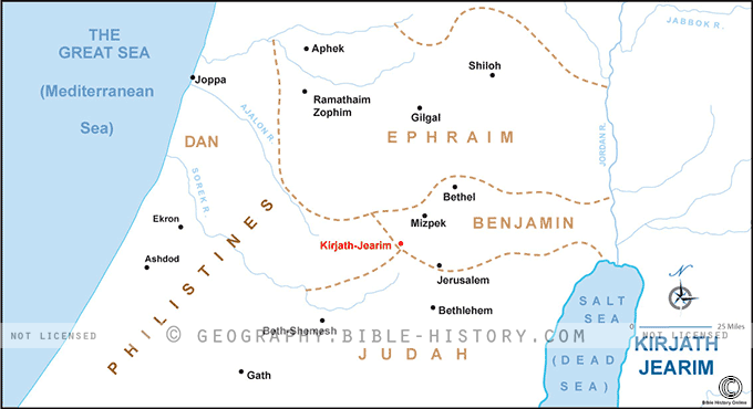

The map of Kirjath Jearim offers a compelling visual representation of a significant ancient city, often mentioned in the Old Testament of the Bible. Kirjath Jearim, also known as Kiriath Yearim or Baalah, held both historical and religious importance in the region.
Geographical Context:
The map of Kirjath Jearim showcases the city's location within the central hill country of ancient Canaan. Situated west of Jerusalem, it occupies a position that overlooks the fertile valleys and plains of the region.
City of Kirjath Jearim:
The map prominently highlights the ancient city of Kirjath Jearim itself. It was known for its strategic location, perched on a hill, and its role as a regional center for trade, culture, and governance.
The Ark of the Covenant:
Kirjath Jearim is perhaps most famous for its connection to the Ark of the Covenant, which had been captured by the Philistines and later returned to Israel. The map may feature the specific location or shrine where the Ark was kept in Kirjath Jearim before its eventual transfer to Jerusalem.
Religious Significance:
This map offers a visual window into the religious significance of Kirjath Jearim. The Ark's presence in the city symbolized the divine covenant between God and the Israelites and played a central role in their faith and worship.
Cultural and Historical Insights:
Exploring the map provides viewers with insights into the daily life, customs, and governance of the people who lived in Kirjath Jearim during biblical times. It allows for a deeper understanding of the cultural and historical dynamics of the region.
Archaeological Context:
The map also points to the archaeological significance of Kirjath Jearim, where excavations have yielded artifacts and insights into the ancient city's history and the events associated with the Ark of the Covenant.
The map of Kirjath Jearim invites viewers to step into a city that played a crucial role in the religious and cultural life of ancient Israel. It allows them to explore the city's geography, history, and religious significance, providing a rich context for understanding the events and stories that unfolded in this iconic location.
Blank Topo Map of The World
Abraham’s Journey
The Captivity of Judah (586-516 B.C.)
The Fall of Judah 586 B.C.
The Northern Kingdom of Israel
The Southern Kingdom of Judah
The Divided Kingdom
The Fertile Crescent
Ur of the Chaldees
Shechem in Old Testament Times
Prophets, Kings, and Nations
Jesus Last Passover
New Testament Israel
New Testament Places
Old Testament Israel
Provinces of the Roman Empire
Israel during David’s Kingdom
David’s Kingdom
Cities of the New Testament 4
Cities of the New Testament 3
Cities of the New Testament 2
Mediterranean Sea
Cities of the New Testament
First Century Jerusalem
Empire of David and Solomon
David’s Kingdom
Israel Under Rehoboam
Ophir and Tarshish
The Period of the Kings
Ramoth Gilead
Samaria
Solomon’s Temple
Zarephath and MT Carmel
Jabesh Gilead and Tribes
Judah in the Time of David
Kingdom of Saul
Kirjath Jearim
Michmash
Mount Gilboa in the Time of David
Nob Davids Flight
Shiloh
Israel and Judah
Assyrian Empire Under Esarhaddon
Assyrian Empire Under Sennacherib
Captivity of 10 Tribes
Events in 2 Kings
The Khabur River
Israel and Syria
Captives From Judah
Kingdom of Jeroboam
Mesha’s Kingdom
Pharaoh Necho Battles King Josiah at Megiddo
Babylonian, Mede and Persian Empires
Samaria and Nearby Territories
Syria at its Height
Hebron
Mahanaim
1949 Map of Israel With Boundaries
First & Second Journeys of Paul
Journeys of the Apostles
Paul’s Third Missionary Journey
Saul’s Journey to Damascus and Arabia
Paul’s Final Visits
Paul’s 1st Missionary Journey
Paul’s 2nd Missionary Journey
Paul’s 3rd Missionary Journey
Paul’s Voyage to Rome
Phillip Journeys to Samaria and Gaza
Judah at the Time of Amos
Empire of Alexander the Great
Israel Under the Maccabees
Galilee During Maccabees
Idumea Intertestamental Period
Kingdom of the Ptolemies
Kingdom of the Seleucids
Ptolemaic Egypt Seleucid Asia
The Roman World
Kingdom of Ptolemies and Seleucids
The World During the 6TH Century BC
Mount Horeb
The Red Sea
The Exodus
Ezra’s Journey to Restore Jerusalem
Israel and Judah During Hosea’s Time
The Ancient World
Canaan During the Time of Abraham
The City of Shechem
Supposed Location of the Garden of Eden
The Land of Israel in Genesis
The Jordan River
The Kingdom of Nimrod
Mount Ararat and Mesopotamia
The Descendants
Sodom and Gomorrah
The Kingdom of Egypt
The Hamites
The Kingdom of the Hittites
Ur of the Chaldees
Judah at the Time of Haggai
Jesus Passes Through Samaria