
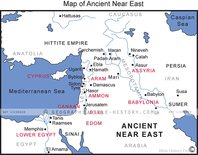
The "Map of the Ancient Near East" is a remarkable cartographic journey that transports you to the cradle of human civilization, where the foundations of culture, history, and innovation were laid. This meticulously crafted map offers a comprehensive exploration of the ancient world's heartland, spanning from the Nile Delta in Egypt to the Tigris and Euphrates rivers in Mesopotamia, encapsulating lands now part of modern-day Egypt, Iraq, Syria, Turkey, and Iran.
Historical and Geographic Context:
Immerse yourself in the rich historical and geographical context of the Ancient Near East, a region often considered the birthplace of human civilization. The map serves as a visual guide to the landscapes and territories that witnessed the rise and fall of empires and the emergence of profound cultural achievements.
Civilizations and Empires:
Explore the great civilizations and empires that flourished in the Ancient Near East, including the Egyptians, Sumerians, Akkadians, Babylonians, Assyrians, Persians, and more. The map highlights their territories and accomplishments, providing a comprehensive overview of their influence on human history.
Cities and Trade Routes:
Discover the vibrant cities and trade routes that connected the region's diverse cultures and facilitated the exchange of goods, ideas, and innovations. Key cities like Ur, Babylon, Thebes, and Jerusalem are prominently featured, reflecting their roles as centers of power and culture.
Natural Features:
The map vividly portrays the diverse natural features of the region, including the life-giving rivers, expansive deserts, fertile plains, and towering mountain ranges. These geographical elements played a pivotal role in the development of ancient civilizations.
Historical Timelines:
Gain a chronological perspective on the rise and fall of empires and dynasties in the Ancient Near East. The map helps you follow the unfolding tapestry of history, from the earliest settlements to the late antiquity period.
Cultural Heritage:
Delve into the rich cultural tapestry of the region, from hieroglyphs and cuneiform script to religious practices, art, architecture, and languages. The map illuminates the diverse expressions of human creativity that flourished in the ancient world.
Archaeological Sites and Discoveries:
Explore archaeological sites and findings associated with the Ancient Near East, symbolizing the ongoing efforts of scholars and archaeologists in unearthing the treasures of this ancient world.
The "Map of the Ancient Near East" offers more than a geographical representation, it's a portal to the cradle of human civilization. Whether you are a historian, an archaeology enthusiast, or someone seeking to understand the roots of our shared human heritage, this map provides a visually engaging and informative journey through the timeless significance of the Ancient Near East, where the past springs to life in a landscape of historical and cultural richness.
Blank Topo Map of The World
Abraham’s Journey
The Captivity of Judah (586-516 B.C.)
The Fall of Judah 586 B.C.
The Northern Kingdom of Israel
The Southern Kingdom of Judah
The Divided Kingdom
The Fertile Crescent
Ur of the Chaldees
Shechem in Old Testament Times
Prophets, Kings, and Nations
Jesus Last Passover
New Testament Israel
New Testament Places
Old Testament Israel
Provinces of the Roman Empire
Israel during David’s Kingdom
David’s Kingdom
Cities of the New Testament 4
Cities of the New Testament 3
Cities of the New Testament 2
Mediterranean Sea
Cities of the New Testament
First Century Jerusalem
Empire of David and Solomon
David’s Kingdom
Israel Under Rehoboam
Ophir and Tarshish
The Period of the Kings
Ramoth Gilead
Samaria
Solomon’s Temple
Zarephath and MT Carmel
Jabesh Gilead and Tribes
Judah in the Time of David
Kingdom of Saul
Kirjath Jearim
Michmash
Mount Gilboa in the Time of David
Nob Davids Flight
Shiloh
Israel and Judah
Assyrian Empire Under Esarhaddon
Assyrian Empire Under Sennacherib
Captivity of 10 Tribes
Events in 2 Kings
The Khabur River
Israel and Syria
Captives From Judah
Kingdom of Jeroboam
Mesha’s Kingdom
Pharaoh Necho Battles King Josiah at Megiddo
Babylonian, Mede and Persian Empires
Samaria and Nearby Territories
Syria at its Height
Hebron
Mahanaim
1949 Map of Israel With Boundaries
First & Second Journeys of Paul
Journeys of the Apostles
Paul’s Third Missionary Journey
Saul’s Journey to Damascus and Arabia
Paul’s Final Visits
Paul’s 1st Missionary Journey
Paul’s 2nd Missionary Journey
Paul’s 3rd Missionary Journey
Paul’s Voyage to Rome
Phillip Journeys to Samaria and Gaza
Judah at the Time of Amos
Empire of Alexander the Great
Israel Under the Maccabees
Galilee During Maccabees
Idumea Intertestamental Period
Kingdom of the Ptolemies
Kingdom of the Seleucids
Ptolemaic Egypt Seleucid Asia
The Roman World
Kingdom of Ptolemies and Seleucids
The World During the 6TH Century BC
Mount Horeb
The Red Sea
The Exodus
Ezra’s Journey to Restore Jerusalem
Israel and Judah During Hosea’s Time
The Ancient World
Canaan During the Time of Abraham
The City of Shechem
Supposed Location of the Garden of Eden
The Land of Israel in Genesis
The Jordan River
The Kingdom of Nimrod
Mount Ararat and Mesopotamia
The Descendants
Sodom and Gomorrah
The Kingdom of Egypt
The Hamites
The Kingdom of the Hittites
Ur of the Chaldees
Judah at the Time of Haggai
Jesus Passes Through Samaria