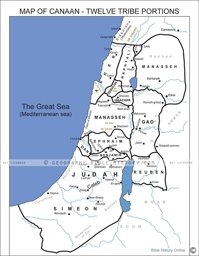

The "Map of Canaan Twelve Tribe Portions" is a captivating and historically significant cartographic masterpiece that provides an immersive journey into the intricate division of the Promised Land among the twelve tribes of Israel, as described in the Bible. This meticulously designed map offers a vivid portrayal of the land allocation and boundaries that defined the inheritance of each tribe, showcasing the cultural, geographical, and historical significance of Canaan.
- Historical and Biblical Context: Immerse yourself in the rich historical and biblical context surrounding the division of Canaan among the twelve tribes of Israel. The map serves as a visual guide to the land inheritance described in the Old Testament, providing a deeper understanding of this pivotal biblical narrative.
- Geographical Diversity: Explore the diverse landscapes of Canaan, from fertile valleys to arid desert regions. The map vividly portrays the topographical features that shaped the geographical boundaries of each tribe's portion, emphasizing the diverse terrains that became the heritage of the Israelite tribes.
- Tribe Territories and Boundaries: Discover the territories and boundaries of each of the twelve tribes, meticulously outlined and color-coded on the map. This feature allows you to trace the land allocations and understand the unique areas assigned to each tribe.
- Cities and Landmarks: Explore the cities, towns, and landmarks within each tribe's portion, providing insights into the cultural, historical, and strategic significance of these locations in the biblical narrative.
- Historical Annotations: Informative annotations and labels offer biblical references, historical context, and explanations for key locations and events associated with the twelve tribes. This makes the map accessible to both scholars and those interested in biblical history.
- Tribal Names and Symbols: Each tribe's name is prominently displayed along with its unique tribal symbol, enhancing the map's visual appeal and aiding in easy identification of tribal territories.
- Cultural Significance: Delve into the cultural and religious significance of the land divisions and the role they played in the formation of the Israelite nation. The map highlights the sacred connection between the tribes and their allotted territories.
- Archaeological Discoveries: Explore archaeological sites and findings associated with Canaan and the tribes of Israel. These markers symbolize the ongoing efforts of archaeologists in uncovering the historical roots of this ancient land.
The "Map of Canaan Twelve Tribe Portions" is not just a geographical representation; it's a profound exploration of a significant biblical narrative that has shaped the identity and heritage of the Israelite people. Whether you are a student of biblical history, a religious scholar, or someone seeking to understand the spiritual and cultural legacy of Canaan, this map offers a captivating visual journey through the division of the Promised Land among the twelve tribes of Israel.
Blank Topo Map of The World
Abraham’s Journey
The Captivity of Judah (586-516 B.C.)
The Fall of Judah 586 B.C.
The Northern Kingdom of Israel
The Southern Kingdom of Judah
The Divided Kingdom
The Fertile Crescent
Ur of the Chaldees
Shechem in Old Testament Times
Prophets, Kings, and Nations
Jesus Last Passover
New Testament Israel
New Testament Places
Old Testament Israel
Provinces of the Roman Empire
Israel during David’s Kingdom
David’s Kingdom
Cities of the New Testament 4
Cities of the New Testament 3
Cities of the New Testament 2
Mediterranean Sea
Cities of the New Testament
First Century Jerusalem
Empire of David and Solomon
David’s Kingdom
Israel Under Rehoboam
Ophir and Tarshish
The Period of the Kings
Ramoth Gilead
Samaria
Solomon’s Temple
Zarephath and MT Carmel
Jabesh Gilead and Tribes
Judah in the Time of David
Kingdom of Saul
Kirjath Jearim
Michmash
Mount Gilboa in the Time of David
Nob Davids Flight
Shiloh
Israel and Judah
Assyrian Empire Under Esarhaddon
Assyrian Empire Under Sennacherib
Captivity of 10 Tribes
Events in 2 Kings
The Khabur River
Israel and Syria
Captives From Judah
Kingdom of Jeroboam
Mesha’s Kingdom
Pharaoh Necho Battles King Josiah at Megiddo
Babylonian, Mede and Persian Empires
Samaria and Nearby Territories
Syria at its Height
Hebron
Mahanaim
1949 Map of Israel With Boundaries
First & Second Journeys of Paul
Journeys of the Apostles
Paul’s Third Missionary Journey
Saul’s Journey to Damascus and Arabia
Paul’s Final Visits
Paul’s 1st Missionary Journey
Paul’s 2nd Missionary Journey
Paul’s 3rd Missionary Journey
Paul’s Voyage to Rome
Phillip Journeys to Samaria and Gaza
Judah at the Time of Amos
Empire of Alexander the Great
Israel Under the Maccabees
Galilee During Maccabees
Idumea Intertestamental Period
Kingdom of the Ptolemies
Kingdom of the Seleucids
Ptolemaic Egypt Seleucid Asia
The Roman World
Kingdom of Ptolemies and Seleucids
The World During the 6TH Century BC
Mount Horeb
The Red Sea
The Exodus
Ezra’s Journey to Restore Jerusalem
Israel and Judah During Hosea’s Time
The Ancient World
Canaan During the Time of Abraham
The City of Shechem
Supposed Location of the Garden of Eden
The Land of Israel in Genesis
The Jordan River
The Kingdom of Nimrod
Mount Ararat and Mesopotamia
The Descendants
Sodom and Gomorrah
The Kingdom of Egypt
The Hamites
The Kingdom of the Hittites
Ur of the Chaldees
Judah at the Time of Haggai
Jesus Passes Through Samaria