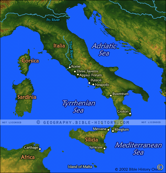

The map of the Mediterranean Sea offers a captivating visual representation of one of the most historically significant bodies of water in the world. The Mediterranean Sea served as a central conduit for trade, travel, and cultural exchange during the biblical era, connecting diverse regions and civilizations. Here is a description of this historical map:
Geographical Scope:
This map provides an expansive view of the Mediterranean Sea, encompassing the coastal regions of the surrounding continents, including Europe, Asia, and Africa. It highlights the Mediterranean Basin, which was home to numerous biblical lands and cultures.
Trade and Commerce:
The map showcases the maritime trade routes and commercial activities that thrived along the Mediterranean shores. It reflects the bustling ports, market towns, and trading hubs that facilitated the exchange of goods, ideas, and cultures.
Coastal Cities and Regions:
It features the coastal cities and regions of biblical significance, such as Alexandria in Egypt, Tyre and Sidon in Phoenicia, Athens in Greece, and many others that were mentioned in the Bible or played a role in ancient biblical narratives.
Cultural Exchange:
The map reflects the rich tapestry of cultures, languages, and religions that coexisted and interacted along the Mediterranean's shores. It was a crossroads of civilizations, where peoples from different backgrounds met, traded, and shared their knowledge and beliefs.
Religious Significance:
This map serves as a visual testament to the religious significance of the Mediterranean Sea, as it played a role in the biblical narratives of journeys, missions, and the spread of faith. It was a backdrop to events involving the Apostle Paul and early Christian communities.
Historical Context:
The map provides historical context for the Mediterranean Sea during biblical times, including its role in the rise and fall of empires, such as the Egyptian, Phoenician, Greek, and Roman civilizations.
Maritime Exploration:
It outlines the routes and journeys of ancient mariners and explorers who ventured across the Mediterranean, contributing to the knowledge of geography and navigation.
Natural Features:
The map may highlight natural features of the Mediterranean, such as islands, straits, and coastal geography, that were relevant to biblical stories and historical events.
The map of the Mediterranean Sea invites viewers to embark on a journey through a vital and dynamic body of water that shaped the destiny of ancient civilizations and played a significant role in the biblical narrative. It allows them to explore the geography, history, and cultural context of this iconic sea, enriching their understanding of the interconnectedness of biblical lands and cultures.
Blank Topo Map of The World
Abraham’s Journey
The Captivity of Judah (586-516 B.C.)
The Fall of Judah 586 B.C.
The Northern Kingdom of Israel
The Southern Kingdom of Judah
The Divided Kingdom
The Fertile Crescent
Ur of the Chaldees
Shechem in Old Testament Times
Prophets, Kings, and Nations
Jesus Last Passover
New Testament Israel
New Testament Places
Old Testament Israel
Provinces of the Roman Empire
Israel during David’s Kingdom
David’s Kingdom
Cities of the New Testament 4
Cities of the New Testament 3
Cities of the New Testament 2
Mediterranean Sea
Cities of the New Testament
First Century Jerusalem
Empire of David and Solomon
David’s Kingdom
Israel Under Rehoboam
Ophir and Tarshish
The Period of the Kings
Ramoth Gilead
Samaria
Solomon’s Temple
Zarephath and MT Carmel
Jabesh Gilead and Tribes
Judah in the Time of David
Kingdom of Saul
Kirjath Jearim
Michmash
Mount Gilboa in the Time of David
Nob Davids Flight
Shiloh
Israel and Judah
Assyrian Empire Under Esarhaddon
Assyrian Empire Under Sennacherib
Captivity of 10 Tribes
Events in 2 Kings
The Khabur River
Israel and Syria
Captives From Judah
Kingdom of Jeroboam
Mesha’s Kingdom
Pharaoh Necho Battles King Josiah at Megiddo
Babylonian, Mede and Persian Empires
Samaria and Nearby Territories
Syria at its Height
Hebron
Mahanaim
1949 Map of Israel With Boundaries
First & Second Journeys of Paul
Journeys of the Apostles
Paul’s Third Missionary Journey
Saul’s Journey to Damascus and Arabia
Paul’s Final Visits
Paul’s 1st Missionary Journey
Paul’s 2nd Missionary Journey
Paul’s 3rd Missionary Journey
Paul’s Voyage to Rome
Phillip Journeys to Samaria and Gaza
Judah at the Time of Amos
Empire of Alexander the Great
Israel Under the Maccabees
Galilee During Maccabees
Idumea Intertestamental Period
Kingdom of the Ptolemies
Kingdom of the Seleucids
Ptolemaic Egypt Seleucid Asia
The Roman World
Kingdom of Ptolemies and Seleucids
The World During the 6TH Century BC
Mount Horeb
The Red Sea
The Exodus
Ezra’s Journey to Restore Jerusalem
Israel and Judah During Hosea’s Time
The Ancient World
Canaan During the Time of Abraham
The City of Shechem
Supposed Location of the Garden of Eden
The Land of Israel in Genesis
The Jordan River
The Kingdom of Nimrod
Mount Ararat and Mesopotamia
The Descendants
Sodom and Gomorrah
The Kingdom of Egypt
The Hamites
The Kingdom of the Hittites
Ur of the Chaldees
Judah at the Time of Haggai
Jesus Passes Through Samaria