
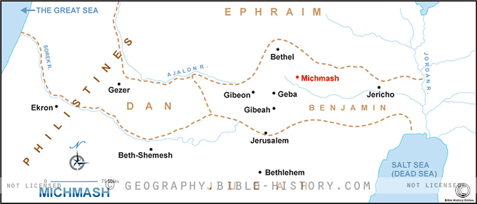
The map of Michmash provides a captivating glimpse into the geographical and historical context of this ancient site, which is prominently featured in the Old Testament. Michmash is best known as the setting for significant events involving the Israelites, particularly during the time of King Saul and his son Jonathan. Here is a description of this historical map:
Geographical Setting:
The map of Michmash portrays the geographical features of this region in ancient Israel. Michmash is located in the central hill country of Israel, east of Jerusalem and not far from the border with the Philistine territory.
Key Locations and Features:
- City of Michmash: The map prominently highlights the ancient city of Michmash itself, which was strategically positioned along a key pass in the hill country. It served as a critical point of control and a potential gateway for invading armies.
- Machmas Pass: This pass, often referred to as the "Pass of Michmash," was a narrow and rugged corridor through which armies, merchants, and travelers would traverse. It played a pivotal role in several biblical narratives.
- Saul and Jonathan's Victory: The map may include markers or depictions of the locations where Saul and Jonathan achieved a significant victory against the Philistine garrison stationed at Michmash, as described in the Bible.
Strategic Significance:
Michmash's strategic importance is a central theme in biblical accounts. It served as a natural fortress and a key control point for those traveling between the central highlands and the Jordan Valley. Its significance is evident in various narratives involving Saul and Jonathan's military exploits.
Cultural and Historical Insights:
Exploring the map offers viewers insights into the military strategies, leadership dynamics, and the challenges faced by the Israelites during the time of Saul and Jonathan. It provides a cultural and historical lens through which to view the ancient world.
Religious Significance:
Michmash also holds religious significance as the backdrop for the faith and courage demonstrated by Jonathan and his armor-bearer, as well as the unfolding of divine providence in the biblical narrative.
Modern Archaeological Discoveries:
The map invites viewers to consider the archaeological excavations and findings at the site of Michmash, which have contributed to our understanding of the history and events that unfolded there.
The map of Michmash offers a compelling journey into a location that played a crucial role in the biblical narratives. It allows viewers to immerse themselves in the terrain and events of this iconic site, where the valor of Saul and Jonathan and the providence of God intersected with the rugged landscape of ancient Israel.
Blank Topo Map of The World
Abraham’s Journey
The Captivity of Judah (586-516 B.C.)
The Fall of Judah 586 B.C.
The Northern Kingdom of Israel
The Southern Kingdom of Judah
The Divided Kingdom
The Fertile Crescent
Ur of the Chaldees
Shechem in Old Testament Times
Prophets, Kings, and Nations
Jesus Last Passover
New Testament Israel
New Testament Places
Old Testament Israel
Provinces of the Roman Empire
Israel during David’s Kingdom
David’s Kingdom
Cities of the New Testament 4
Cities of the New Testament 3
Cities of the New Testament 2
Mediterranean Sea
Cities of the New Testament
First Century Jerusalem
Empire of David and Solomon
David’s Kingdom
Israel Under Rehoboam
Ophir and Tarshish
The Period of the Kings
Ramoth Gilead
Samaria
Solomon’s Temple
Zarephath and MT Carmel
Jabesh Gilead and Tribes
Judah in the Time of David
Kingdom of Saul
Kirjath Jearim
Michmash
Mount Gilboa in the Time of David
Nob Davids Flight
Shiloh
Israel and Judah
Assyrian Empire Under Esarhaddon
Assyrian Empire Under Sennacherib
Captivity of 10 Tribes
Events in 2 Kings
The Khabur River
Israel and Syria
Captives From Judah
Kingdom of Jeroboam
Mesha’s Kingdom
Pharaoh Necho Battles King Josiah at Megiddo
Babylonian, Mede and Persian Empires
Samaria and Nearby Territories
Syria at its Height
Hebron
Mahanaim
1949 Map of Israel With Boundaries
First & Second Journeys of Paul
Journeys of the Apostles
Paul’s Third Missionary Journey
Saul’s Journey to Damascus and Arabia
Paul’s Final Visits
Paul’s 1st Missionary Journey
Paul’s 2nd Missionary Journey
Paul’s 3rd Missionary Journey
Paul’s Voyage to Rome
Phillip Journeys to Samaria and Gaza
Judah at the Time of Amos
Empire of Alexander the Great
Israel Under the Maccabees
Galilee During Maccabees
Idumea Intertestamental Period
Kingdom of the Ptolemies
Kingdom of the Seleucids
Ptolemaic Egypt Seleucid Asia
The Roman World
Kingdom of Ptolemies and Seleucids
The World During the 6TH Century BC
Mount Horeb
The Red Sea
The Exodus
Ezra’s Journey to Restore Jerusalem
Israel and Judah During Hosea’s Time
The Ancient World
Canaan During the Time of Abraham
The City of Shechem
Supposed Location of the Garden of Eden
The Land of Israel in Genesis
The Jordan River
The Kingdom of Nimrod
Mount Ararat and Mesopotamia
The Descendants
Sodom and Gomorrah
The Kingdom of Egypt
The Hamites
The Kingdom of the Hittites
Ur of the Chaldees
Judah at the Time of Haggai
Jesus Passes Through Samaria