
History is a tapestry woven with the threads of time, and understanding our past helps us make sense of the present. One fascinating piece of this historical puzzle is the "Map of the Territory of the Amalekites." It offers us a glimpse into the ancient world, shedding light on the Amalekites, a people mentioned in several religious texts, including the Bible. Join us on a journey to explore the significance of this map and the enigmatic Amalekites.
Who Were the Amalekites?
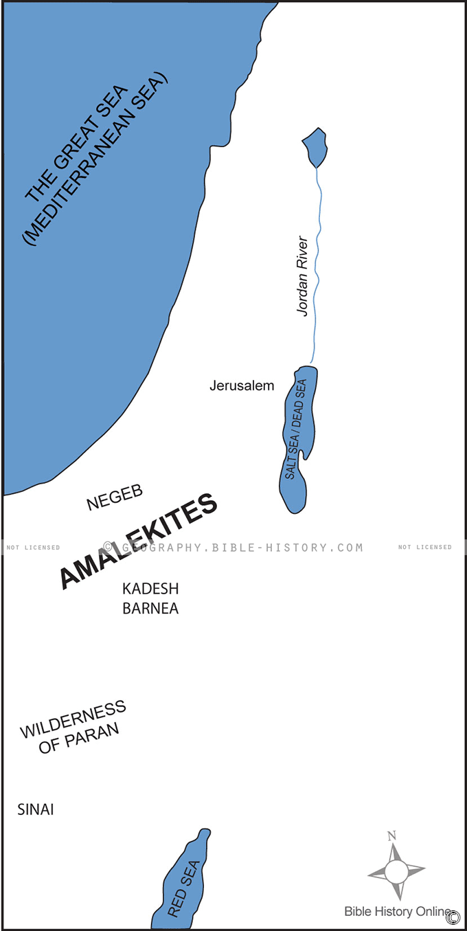
The Amalekites were a nomadic people who inhabited the region known as the Negev Desert in present-day southern Israel. They are a prominent group in the Bible, mentioned in the Old Testament. Their most well-known encounter in the Bible was with the Israelites during the Exodus, where they are depicted as a formidable adversary. The Amalekites' existence has been a subject of historical debate, as they left behind few archaeological remnants.
The Significance of the Map:
The "Map of the Territory of the Amalekites" has garnered attention for several reasons:
Historical Context:
This map provides geographical insights into the region where the Amalekites lived. It offers a visual representation of their territory, which is invaluable for understanding their place in ancient history.
Biblical Connection:
For those interested in biblical history, the map serves as a tangible link to the events and peoples mentioned in the Bible. It helps us better visualize the places where significant biblical narratives unfolded.
Archaeological Clues:
Although the Amalekites remain a somewhat elusive group in archaeological records, this map can help archaeologists and historians focus their efforts on specific regions where Amalekite artifacts or remnants might be found.
Cultural Exploration:
Maps like these are not only historical artifacts but also cultural treasures. They give us insights into the cartography and artistic styles of the period when they were created.
Exploring the Territory:
The territory of the Amalekites is believed to have included parts of the Negev Desert and the southern regions of ancient Canaan. They were known as semi-nomadic pastoralists, which means they moved with their herds of livestock in search of grazing land and water sources. This map likely reflects their seasonal migrations and settlements.
The "Map of the Territory of the Amalekites" is a captivating window into the ancient world. It allows us to connect with a people whose history is intertwined with biblical narratives and to explore the geography of a region that has seen millennia of human activity. While the Amalekites themselves may remain somewhat elusive, this map provides an essential piece of the puzzle in understanding their existence and significance in ancient history.
Blank Topo Map of The World
Abraham’s Journey
The Captivity of Judah (586-516 B.C.)
The Fall of Judah 586 B.C.
The Northern Kingdom of Israel
The Southern Kingdom of Judah
The Divided Kingdom
The Fertile Crescent
Ur of the Chaldees
Shechem in Old Testament Times
Prophets, Kings, and Nations
Jesus Last Passover
New Testament Israel
New Testament Places
Old Testament Israel
Provinces of the Roman Empire
Israel during David’s Kingdom
David’s Kingdom
Cities of the New Testament 4
Cities of the New Testament 3
Cities of the New Testament 2
Mediterranean Sea
Cities of the New Testament
First Century Jerusalem
Empire of David and Solomon
David’s Kingdom
Israel Under Rehoboam
Ophir and Tarshish
The Period of the Kings
Ramoth Gilead
Samaria
Solomon’s Temple
Zarephath and MT Carmel
Jabesh Gilead and Tribes
Judah in the Time of David
Kingdom of Saul
Kirjath Jearim
Michmash
Mount Gilboa in the Time of David
Nob Davids Flight
Shiloh
Israel and Judah
Assyrian Empire Under Esarhaddon
Assyrian Empire Under Sennacherib
Captivity of 10 Tribes
Events in 2 Kings
The Khabur River
Israel and Syria
Captives From Judah
Kingdom of Jeroboam
Mesha’s Kingdom
Pharaoh Necho Battles King Josiah at Megiddo
Babylonian, Mede and Persian Empires
Samaria and Nearby Territories
Syria at its Height
Hebron
Mahanaim
1949 Map of Israel With Boundaries
First & Second Journeys of Paul
Journeys of the Apostles
Paul’s Third Missionary Journey
Saul’s Journey to Damascus and Arabia
Paul’s Final Visits
Paul’s 1st Missionary Journey
Paul’s 2nd Missionary Journey
Paul’s 3rd Missionary Journey
Paul’s Voyage to Rome
Phillip Journeys to Samaria and Gaza
Judah at the Time of Amos
Empire of Alexander the Great
Israel Under the Maccabees
Galilee During Maccabees
Idumea Intertestamental Period
Kingdom of the Ptolemies
Kingdom of the Seleucids
Ptolemaic Egypt Seleucid Asia
The Roman World
Kingdom of Ptolemies and Seleucids
The World During the 6TH Century BC
Mount Horeb
The Red Sea
The Exodus
Ezra’s Journey to Restore Jerusalem
Israel and Judah During Hosea’s Time
The Ancient World
Canaan During the Time of Abraham
The City of Shechem
Supposed Location of the Garden of Eden
The Land of Israel in Genesis
The Jordan River
The Kingdom of Nimrod
Mount Ararat and Mesopotamia
The Descendants
Sodom and Gomorrah
The Kingdom of Egypt
The Hamites
The Kingdom of the Hittites
Ur of the Chaldees
Judah at the Time of Haggai
Jesus Passes Through Samaria