
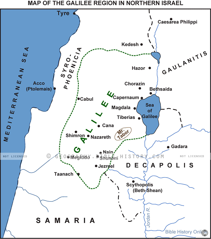
The Map of the Galilee Region in Northern Israel offers a remarkable journey back in history to the ancient world of the Galilee. This meticulously crafted map provides a unique window into the landscape, settlements, and significant landmarks as they existed during the biblical era. It serves as a valuable resource for historians, archaeologists, theologians, and anyone interested in understanding the rich historical tapestry of this sacred land.
Historical Context:
The map transports viewers to a time when the Galilee was a center of ancient civilization, offering context for understanding the stories and events recounted in the Bible.
Biblical Sites:
Iconic biblical sites are clearly marked, including Capernaum, where Jesus performed miracles, and Cana, the site of the famous wedding feast.
Cities and Villages:
Ancient cities such as Tiberias, which existed during biblical times, are highlighted, as well as smaller villages and settlements of historical significance.
Trade Routes:
Ancient trade routes, vital for the region's commerce and cultural exchange, are illustrated, shedding light on the economic dynamics of the time.
Religious and Spiritual Sites:
The map identifies important religious and spiritual sites, such as synagogues and places of worship that played a central role in the lives of biblical figures.
Historical Borders:
The map outlines the historical boundaries and territories, allowing viewers to understand the geopolitical landscape of biblical Galilee.
Natural Features:
Prominent natural features like the Sea of Galilee (Kinneret), rivers, and mountain ranges are depicted to underscore their significance in biblical narratives.
Land of Prophets and Patriarchs:
Markers indicate locations associated with biblical figures like Elijah, Elisha, and the patriarchs, connecting viewers to the stories of faith and prophecy.
The Map of the Galilee Region in Northern Israel is a captivating portal to an age when the Galilee was at the crossroads of history, culture, and faith. It invites exploration and contemplation of the events and figures that shaped the religious and historical narrative of this hallowed land. Whether you seek to deepen your biblical understanding or simply want to immerse yourself in the world of antiquity, this map provides an invaluable resource for unraveling the mysteries of the Galilee's past. It's a bridge between modernity and the timeless tales of the Bible that continue to inspire and resonate today.
Blank Topo Map of The World
Abraham’s Journey
The Captivity of Judah (586-516 B.C.)
The Fall of Judah 586 B.C.
The Northern Kingdom of Israel
The Southern Kingdom of Judah
The Divided Kingdom
The Fertile Crescent
Ur of the Chaldees
Shechem in Old Testament Times
Prophets, Kings, and Nations
Jesus Last Passover
New Testament Israel
New Testament Places
Old Testament Israel
Provinces of the Roman Empire
Israel during David’s Kingdom
David’s Kingdom
Cities of the New Testament 4
Cities of the New Testament 3
Cities of the New Testament 2
Mediterranean Sea
Cities of the New Testament
First Century Jerusalem
Empire of David and Solomon
David’s Kingdom
Israel Under Rehoboam
Ophir and Tarshish
The Period of the Kings
Ramoth Gilead
Samaria
Solomon’s Temple
Zarephath and MT Carmel
Jabesh Gilead and Tribes
Judah in the Time of David
Kingdom of Saul
Kirjath Jearim
Michmash
Mount Gilboa in the Time of David
Nob Davids Flight
Shiloh
Israel and Judah
Assyrian Empire Under Esarhaddon
Assyrian Empire Under Sennacherib
Captivity of 10 Tribes
Events in 2 Kings
The Khabur River
Israel and Syria
Captives From Judah
Kingdom of Jeroboam
Mesha’s Kingdom
Pharaoh Necho Battles King Josiah at Megiddo
Babylonian, Mede and Persian Empires
Samaria and Nearby Territories
Syria at its Height
Hebron
Mahanaim
1949 Map of Israel With Boundaries
First & Second Journeys of Paul
Journeys of the Apostles
Paul’s Third Missionary Journey
Saul’s Journey to Damascus and Arabia
Paul’s Final Visits
Paul’s 1st Missionary Journey
Paul’s 2nd Missionary Journey
Paul’s 3rd Missionary Journey
Paul’s Voyage to Rome
Phillip Journeys to Samaria and Gaza
Judah at the Time of Amos
Empire of Alexander the Great
Israel Under the Maccabees
Galilee During Maccabees
Idumea Intertestamental Period
Kingdom of the Ptolemies
Kingdom of the Seleucids
Ptolemaic Egypt Seleucid Asia
The Roman World
Kingdom of Ptolemies and Seleucids
The World During the 6TH Century BC
Mount Horeb
The Red Sea
The Exodus
Ezra’s Journey to Restore Jerusalem
Israel and Judah During Hosea’s Time
The Ancient World
Canaan During the Time of Abraham
The City of Shechem
Supposed Location of the Garden of Eden
The Land of Israel in Genesis
The Jordan River
The Kingdom of Nimrod
Mount Ararat and Mesopotamia
The Descendants
Sodom and Gomorrah
The Kingdom of Egypt
The Hamites
The Kingdom of the Hittites
Ur of the Chaldees
Judah at the Time of Haggai
Jesus Passes Through Samaria